• Ever wanted an RSS feed of all your favorite gaming news sites? Go check out our new Gaming Headlines feed! Read more about it here.
  • We have made minor adjustments to how the search bar works on ResetEra. You can read about the changes here.

ViewtifulJux

Member
Oct 25, 2017
537
Gonna hit up Walmart in Wilmington tonight, hopefully get there when they start restocking.

I still have more bullshit to do with my uncle's boat tomorrow when I should be readying up and deciding to head out or not. Some of my friends are staying and others have family North of us where it will probably be worse.

Bless up ILM fam, gotta say I'm glad I'm not there anymore for this kinda shit. I bet the Wally World by Campus is absolutely bonkers. Worried for my family in the area but they live a little more inland. Not much more though and are likely more prone to flooding than Wilmington actually. Stay safe down there.
 

DukeBlue

Banned
Nov 6, 2017
1,502
Classes at a neighboring school, UNC Chapel Hill, just cancelled classes after 5 Tuesday till Friday and they are planning to evacuate the entire school. Here at Duke we plan on hunkering down and hoping these old buildings can take some wind
 
Oct 25, 2017
12,463
Yeah just go ahead and delete North Carolina like that, no biggie
uvou947.gif
 

Radd Redd

Member
Oct 27, 2017
8,006
Zone D, so we're good for now. Work is in Zone A. They called and said I'm off and getting paid until the 16th.
 

hom3land

Member
Oct 27, 2017
2,589
It feels like North Carolina isn't taking this seriously at all. Why isn't there a mandatory evacuation for wilmington? They just announced it for Carolina Beach. Why wasn't it announced early today?


On a bright side it poured here in raleigh, and suppose to rain tomorrow too. Ground and trees will be nice and wet when it hits here.......
 

Manzoon

Member
Oct 25, 2017
1,197
East Coast, USA
Bless up ILM fam, gotta say I'm glad I'm not there anymore for this kinda shit. I bet the Wally World by Campus is absolutely bonkers. Worried for my family in the area but they live a little more inland. Not much more though and are likely more prone to flooding than Wilmington actually. Stay safe down there.
Thanks man, definitely not going to that one, it's an adventure at the best of times. Out and about getting a super late dinner at cookout. Lots of places closed early today.

Every gas station I've passed has been slammed tonight.
 

FeenixRisen

McDonalds looks really average next to Wendys
Member
Oct 25, 2017
1,487
VA implemented the evacuation zone plans not too long ago it seems (last year actually).

Prior to that, the main idea was to use the I-64 contraflow lanes and evacuate all of Hampton Roads. But getting 1.3 million people out the area was not very feasible.

So they instituted the zones ranging from Zone A (most prone to flooding) to Zone D (least prone) so they can evacuate people in a certain order.

Right now only Zone A is being evacuated which includes people like myself. I'm not going far, only to an extended stay located in a Zone D.
 

Teiresias

Member
Oct 27, 2017
8,221
VA implemented the evacuation zone plans not too long ago it seems (last year actually).

Prior to that, the main idea was to use the I-64 contraflow lanes and evacuate all of Hampton Roads. But getting 1.3 million people out the area was not very feasible.

So they instituted the zones ranging from Zone A (most prone to flooding) to Zone D (least prone) so they can evacuate people in a certain order.

Right now only Zone A is being evacuated which includes people like myself. I'm not going far, only to an extended stay located in a Zone D.

The reversing of lanes on I-64 is still part of the overall evacuation plan if required, they just never had an easy nomenclature for ordering evacuations that was easy for people to follow. If they really had to prior to the Zones I'm sure they'd have done specific localities merely based on zip codes or something, which isn't as granular nor as focused based on who is most at risk for storm surge and tidal flooding.
 

Tobor

Member
Oct 25, 2017
28,484
Richmond, VA
I made it out of Wilmington and am back in Richmond, thank goodness. Now I just have to prepare for the potential flooding and power outage.
 

Rebel1

Member
Oct 25, 2017
3,234
Florence still at 140 mph
944 mb (a very slight decrease was 939 6 hours ago)

Looks like they expect a slowdown in movement speed

Error cone slightly jumped north
EUFJlXf.png
 
Last edited:

Deleted member 1086

User requested account closure
Banned
Oct 25, 2017
14,796
Boise Area, Idaho
even with reversing the lanes getting out of Norfolk/VA Beach would be a nightmare. Add a wreck or two and it would be damn near impossible.

I once made the mistake of trying to leave town on the Wednesday afternoon before Thanksgiving to go south, took me like two hours to get out of town and out to Emporia to jump on 95, via 264/64/hwy-58. It was then that I realized how much the exit strategy from Norfolk sucked.
 
OP
OP
perfectchaos007

perfectchaos007

It's Happening
Member
Oct 25, 2017
12,243
Texas
I was told that 20 inches of rain is more like 60 inches of rain in the carolinas due to the mountains with mudslides and runoffs.......
We could have one of the worst floods in US history on our hands. Don't take chances with this people
 

Maquiladora

Member
Nov 16, 2017
5,092
The latest euro model is bad fucking news. Hits Wilmington as a major hurricane then stalls for 24 hours just inland, still maintaining hurricane strength instead of rapidly weakening because half the storm is still out over the ocean. 24 hours after that, it's just moved further down the coast over the border into SC and still in the low 980mb range. 24 hours after that, it's finally further inland over SC....Dumps 40+ inches of rain over the Wilmington area.

Unfortunately the Euro model can't be dismissed and the idea of some kind of extreme slowdown/stall/loop is looking a lot more likely.
 

Irminsul

Member
Oct 25, 2017
3,039
The latest euro model is bad fucking news. Hits Wilmington as a major hurricane then stalls for 24 hours just inland, still maintaining hurricane strength instead of rapidly weakening because half the storm is still out over the ocean. 24 hours after that, it's just moved further down the coast over the border into SC and still in the low 980mb range. 24 hours after that, it's finally further inland over SC....Dumps 40+ inches of rain over the Wilmington area.

Unfortunately the Euro model can't be dismissed and the idea of some kind of extreme slowdown/stall/loop is looking a lot more likely.
Woha, you're right, that's quite a sight:

de_model-de-310-1_modi2fsd.png

(Accumulated rainfall until Sunday night)

Apologies for metric units to my fellow Americans ;) 500 mm are roughly 20 inches, so 1000 are 40 and the maximum of 1178 is 46.37 inches.
 

Nathan_Drake

Member
Nov 6, 2017
431
I am in Charleston. This drop to the west and south after a stall is crazy. Even the GFS has it now but it starts more north so less impact here. The Euro model would be crazy.
 

Miggytronz

Member
Oct 26, 2017
1,642
Virginia Beach, VA
So, err, what's this guy's knowledge of the topic? Except for claiming to be a meteorologist.

This is his bio: "An ordained evangelist passionate about the Bible being the solution to yours and our countries problems."

He as a meteorologist for my area since 1987. I was 5 yrs old. He quit a few years ago to open a church.

He posted this yesterday......
From Jon Cash
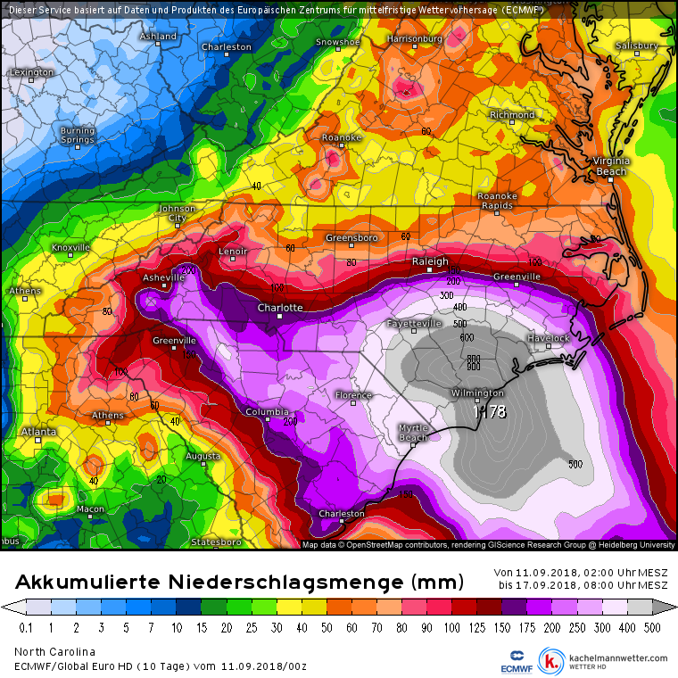
A Hurricane Florence update: Once again, no good news...only bad. The storm is rapidly strengthening and is now a category four hurricane. ALL models paint this getting bigger in the next 24 hours. It will approach the coast Thursday evening and slow down to a crawl. Nobody knows if it will be a category three, four, or five storm when it makes landfall. There are three possibilities with this storm.

1. It comes ashore near Myrtle Beach and goes inland very slowly. Utter destruction around where the eye comes ashore. Outer Banks spared and Hampton Roads spared. Inland SC and NC devastated with days of torrential rains.

2. It comes ashore near Wilmington or Jacksonville NC. Horrible destruction from high winds and 15-20 foot storm surge near the eye landfall location. Outer Banks hit with 5-8 foot storm surge and winds strong enough to knock down trees but not destroy or damage too many buildings. Hampton Roads would experience similar conditions to Isabel a decade ago with flooding and many power outages and lots of rainfall flooding but otherwise spared the worst. Inland NC and VA including the mountains would experience massive flooding that could kill dozens or hundreds depending on where the worst rainfall sets up. It could last for three or four days in these inland areas because the storm stalls out.

3. It hovers off the Cape Hatteras seashore of NC for 24-48 hours before slowly moving west. If the eye grazes the coast and sits for a prolonged period of time as a category four or five, it would completely destroy the southern part of the Outer Banks including Rodanthe and Hatteras. Anybody staying would most likely lose their lives. Nags Head and points north would have destruction that has not been seen in over 100 years. The big cities in Hampton Roads would experience the worst hurricane in 150 years leading to many fatalities and weeks or months with no power. Once the storm moves inland, the catastrophic flooding would then occur in the mountainous areas.

There is still a glimmer of hope that the storm stalls just far enough off the coast to not reek destruction and then several days later, slowly moves out to sea. The chance of this is under 5%.

Will update again tomorrow evening and do another facebook live in the early evening. Sorry I can't possibly take questions. So..it's till wait and see which one of these solutions pans out.
 

Ambient80

The Fallen
Oct 25, 2017
4,619
My parents have a house on oak island in NC. They got it boarded up and came back home to WV a few days ago. Oak Island is gonna get slammed :(
 

weekev

Is this a test?
Member
Oct 25, 2017
6,215
He as a meteorologist for my area since 1987. I was 5 yrs old. He quit a few years ago to open a church.

He posted this yesterday......
Holy shit, so less than a 5% chance of this to not create absolute devastation. Please stay safe Carolina and Viriginia Era. Dont gamble on this one.
 

Maquiladora

Member
Nov 16, 2017
5,092
Recon just flew into Florence and she has weakened a bit due to an eyewall replacement. But she is expected to strengthen again.
 
Oct 25, 2017
1,086
Gas stations along my commute this morning (Durham to Raleigh) were absolutely slammed - and that was at 5:45 am. I can't imagine what they'll be like later today/tomorrow. After my commute home, I'll still have nearly a full tank so I feel okay about that. Only thing I would really like to get is charcoal; hopefully I can find some tonight/tomorrow morning.
 

Nathan_Drake

Member
Nov 6, 2017
431
Are you evacuating? Or staying put?

I am staying since I am in Summersville. It's about 20 miles inland. I don't live in a flood plain. Even in that bad scenario when it curves down it will be a lot of rain and maybe tropical storm force winds. I live in a solid house.

Crazy schools are out today. We are working remote for the week, thankfully I have that option. Now the storm isn't hitting till Friday and it may be Saturday before we feel it. We are under a Hurricane Watch in Berkeley County.

Some think they may rescind the evacuation for Beaufort, Jasper, and Colleton counties.
 

Kusagari

Member
Oct 25, 2017
18,421
vwaZs86.gif


Here's a gif of the run. I can't even imagine the flooding if it happens. Just days over the Carolina's.
 

dryz

Member
Oct 30, 2017
247
Pressure at 952mb. A new, bigger eye is trying to form. If successful, it could strengthen to cat 5.
 

Zatoichi

Attempted to circumvent ban with alt account
Banned
Oct 25, 2017
1,073
Ireland
Yeah it has two eyes right now. I wonder with it being 2 days out if we could luck into the timing of another eye replacement cycle / weakening just before landfall.

It won't take that long for the eye wall replacement, in fact the timing me be perfect for the worse case scenario. The process has already begun.
 

Nathan_Drake

Member
Nov 6, 2017
431
The difference between the GFS and Euro has been constant. This Twitter thread does an excellent job explaining what the models are doing differently and why the Euro is farther south. I hope next year we can get the best model for the US. It could save lives and lead to better forecasting.

 
Oct 25, 2017
1,086
I am staying since I am in Summersville. It's about 20 miles inland. I don't live in a flood plain. Even in that bad scenario when it curves down it will be a lot of rain and maybe tropical storm force winds. I live in a solid house.

Crazy schools are out today. We are working remote for the week, thankfully I have that option. Now the storm isn't hitting till Friday and it may be Saturday before we feel it. We are under a Hurricane Watch in Berkeley County.

Stay safe, buddy. Are you in the Discord group?
 

Dr.Thunder

Member
Oct 29, 2017
23
I'm also is Summerville, SC. Pretty terrified but I think my house is quite safe. Wanted to get out to Augusta at least but I don't have any transportation so I have no choice but to ride it out....
 

Nathan_Drake

Member
Nov 6, 2017
431
I'm also is Summerville, SC. Pretty terrified but I think my house is quite safe. Wanted to get out to Augusta at least but I don't have any transportation so I have no choice but to ride it out....
They don't have Colleton, Beaufort, or Jasper under Hurricane Watch. Berkeley is but we are one of the most southern counties on there. The real threat to Summerville will be the rain Sat-Mon. Are you in an area you can stay above ground? I hope so. Stay safe!
 

Dr.Thunder

Member
Oct 29, 2017
23
They don't have Colleton, Beaufort, or Jasper under Hurricane Watch. Berkeley is but we are one of the most southern counties on there. The real threat to Summerville will be the rain Sat-Mon. Are you in an area you can stay above ground? I hope so. Stay safe!

I should be fine as far as flooding is concerned. Really worried for some of my friends and family that live in more flood prone locations.
 

Jmdajr

Member
Oct 25, 2017
14,534
I wonder how many people don't have flood insurance. How often do Hurricanes hit there?