-
Ever wanted an RSS feed of all your favorite gaming news sites? Go check out our new Gaming Headlines feed! Read more about it here.
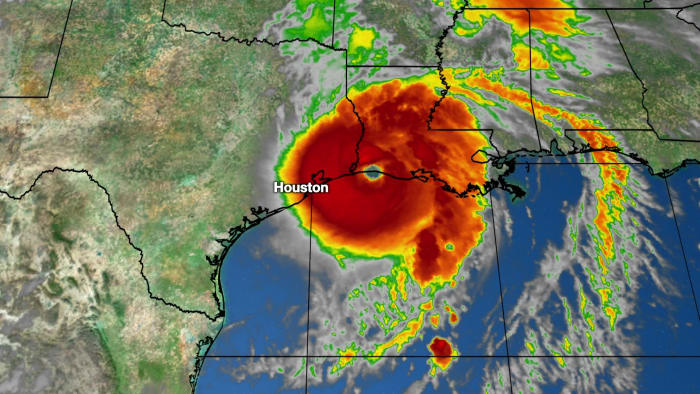
Hurricane Laura |OT| [Up: Category 4]
- Thread starter fluffydelusions
- Start date
- News
You are using an out of date browser. It may not display this or other websites correctly.
You should upgrade or use an alternative browser.
You should upgrade or use an alternative browser.
We are still getting at least tropical storm conditions no matter what, which is not great. But I get it, would be a massive relief to not have to endure hurricane force winds.
I know I'm still going to lose power though (the power goes out if you sneeze where I am). Hopefully this time the power will be restored fast, I REALLY don't want to have no air conditioning when it's going to be 95 degrees every day for the next few weeks.
I haven't been paying attention to this hurricane, but am now though :/

www.weather.com/storms/hurricane/news/2020-08-25-hurricane-laura-forecast-texas-louisiana
www.weather.com/storms/hurricane/news/2020-08-25-hurricane-laura-forecast-texas-louisiana
I'm assuming the pre-cautions made by certain companies/organizations will still remain (i.e. school closures) or what? lol
Yep
Slightly stronger, though it seems its leveled off for now.
10:00 PM CDT Tue Aug 25
Location: 25.2°N 89.5°W
Moving: WNW at 17 mph
Min pressure: 978 mb
Max sustained: 90 mph
10:00 PM CDT Tue Aug 25
Location: 25.2°N 89.5°W
Moving: WNW at 17 mph
Min pressure: 978 mb
Max sustained: 90 mph
Well you know I've been saying I'd drag myself over broken glass to go vote Trump out of office, but I didn't really think I might have to literally do that...
Laura is a category 2 storm and rapidly intensifying according to NHC
1:00 AM CDT Wed Aug 26
Location: 25.6°N 90.2°W
Moving: WNW at 17 mph
Min pressure: 978 mb
Max sustained: 105 mph
1:00 AM CDT Wed Aug 26
Location: 25.6°N 90.2°W
Moving: WNW at 17 mph
Min pressure: 978 mb
Max sustained: 105 mph
Latest Euro model ramps Laura up to 931mb and almost Cat 5 intensity before landfall.
Laura is on her way to becoming extremely dangerous.
Laura is on her way to becoming extremely dangerous.
That's worrying. This is the first one me or my family has ever experienced directly like this, and we are east of Houston proper by about 45-50 minutes or so. Almost equally between Beaumont and Houston's downtown if I were to guess. Essentially we are just above Anahuac and the possibility of a Cat 5 could happen, that's got me quite scared, especially for the possible storm surge and whether or not our house is safe...Latest Euro model ramps Laura up to 931mb and almost Cat 5 intensity before landfall.
Laura is on her way to becoming extremely dangerous.
We boarded up about 2/3rds of the most important, main windows last night and we're going to finish tomorrow in the day, not sure how early. We have a bunch of animals, mainly a bunch of cats and a dog, and we are just sticking put currently. This neighborhood has apparently never super seriously flooded, even though standing water has been in people's yards. I guess most others are staying, but I'm not entirely sure about that either.
I'm with my parents and I followed them down here and had quit my job and everything, right at the beginning of the year. Been kinda fucked by this year, and I hope it doesn't get just that much worse.
Any advice/thoughts/recommendations would be appreciated. Have we made a mistake to stay? I fucking hope not. We don't have any kind of boat, or even life jackets or anything and suddenly I'm thinking that both of those facts are not very good at this moment in time.
I'm not super familiar with the area or it's surrounding waters (what their water line right now is important to how they'll be affected by storm surge) but it looks like you're going to be just barely on the left side of the projections. It looks like you may get hit pretty bad but it's possible you'll avoid damage.That's worrying. This is the first one me or my family has ever experienced directly like this, and we are east of Houston proper by about 45-50 minutes or so. Almost equally between Beaumont and Houston's downtown if I were to guess. Essentially we are just above Anahuac and the possibility of a Cat 5 could happen, that's got me quite scared, especially for the possible storm surge and whether or not our house is safe...
We boarded up about 2/3rds of the most important, main windows last night and we're going to finish tomorrow in the day, not sure how early. We have a bunch of animals, mainly a bunch of cats and a dog, and we are just sticking put currently. This neighborhood has apparently never super seriously flooded, even though standing water has been in people's yards. I guess most others are staying, but I'm not entirely sure about that either.
I'm with my parents and I followed them down here and had quit my job and everything, right at the beginning of the year. Been kinda fucked by this year, and I hope it doesn't get just that much worse.
Any advice/thoughts/recommendations would be appreciated. Have we made a mistake to stay? I fucking hope not. We don't have any kind of boat, or even life jackets or anything and suddenly I'm thinking that both of those facts are not very good at this moment in time.
I'd suggest boarding up all the rest of your windows, especially if Laura stays at this category or gets worse, and make sure you're as stocked up as you can be. Food, water, batteries, charging packs, FM radio (good for weather updates when internet goes down etc). Try to find out where your local shelters are in case you do need to leave the house at some point. Your county will generally have picked secure locations for their shelters. God forbid if the house floods enough you can always go to the second floor or an attic. But if it gets that bad you want to call for help immediately so you're not stuck up there if the water rises any further.
This all general advice from a New Orleanian but don't let me get you too worked up. Others who are tracking the storm may have a better idea of where it's headed I just wanted to give you points on how to prepare
That's worrying. This is the first one me or my family has ever experienced directly like this, and we are east of Houston proper by about 45-50 minutes or so. Almost equally between Beaumont and Houston's downtown if I were to guess. Essentially we are just above Anahuac and the possibility of a Cat 5 could happen, that's got me quite scared, especially for the possible storm surge and whether or not our house is safe...
We boarded up about 2/3rds of the most important, main windows last night and we're going to finish tomorrow in the day, not sure how early. We have a bunch of animals, mainly a bunch of cats and a dog, and we are just sticking put currently. This neighborhood has apparently never super seriously flooded, even though standing water has been in people's yards. I guess most others are staying, but I'm not entirely sure about that either.
I'm with my parents and I followed them down here and had quit my job and everything, right at the beginning of the year. Been kinda fucked by this year, and I hope it doesn't get just that much worse.
Any advice/thoughts/recommendations would be appreciated. Have we made a mistake to stay? I fucking hope not. We don't have any kind of boat, or even life jackets or anything and suddenly I'm thinking that both of those facts are not very good at this moment in time.
If Laura maintains her expected track then you'll experience tropical storm force winds and possibily hurricane force winds depending on how big Laura grows and if she wobbles more west. At the moment, I think it's unlikely that you'll experience major hurricane force winds in that location. Areas further east of you look like getting the core of strong winds. But you should be prepared to have your power knocked out and possibily for days. But in terms of destructive winds, right now, it looks like you will far enough west to miss the worst of the storm.
Looking at the storm surge map (https://www.nhc.noaa.gov/refresh/graphics_at3+shtml/031013.shtml?inundation#contents) it looks like the worst will be further east of you too.
This all depends on the track Laura takes though. So do please keep listening to official forecasts and statements in case of changes.
That's worrying. This is the first one me or my family has ever experienced directly like this, and we are east of Houston proper by about 45-50 minutes or so. Almost equally between Beaumont and Houston's downtown if I were to guess. Essentially we are just above Anahuac and the possibility of a Cat 5 could happen, that's got me quite scared, especially for the possible storm surge and whether or not our house is safe...
We boarded up about 2/3rds of the most important, main windows last night and we're going to finish tomorrow in the day, not sure how early. We have a bunch of animals, mainly a bunch of cats and a dog, and we are just sticking put currently. This neighborhood has apparently never super seriously flooded, even though standing water has been in people's yards. I guess most others are staying, but I'm not entirely sure about that either.
I'm with my parents and I followed them down here and had quit my job and everything, right at the beginning of the year. Been kinda fucked by this year, and I hope it doesn't get just that much worse.
Any advice/thoughts/recommendations would be appreciated. Have we made a mistake to stay? I fucking hope not. We don't have any kind of boat, or even life jackets or anything and suddenly I'm thinking that both of those facts are not very good at this moment in time.
Good sites for information on how to prepare
Hurricanes | Ready.gov
Learn how to prepare for a hurricane, stay safe during a hurricane, and what to do when returning home from a hurricane. Hurricanes are dangerous and can cause major damage because of storm surge, wind damage, and flooding. They can happen along any U.S. coast or in any territory in the Atlantic...
Looking at it unless something drastic changes you'll be on the weak side of the storm and out of the hurricane force wind field, unless you are close to a water source you won't see much flooding as the storm is moving at a good speed. You'll probably get some tropical storm force winds and some gusts at hurricane force as storm bands come through. These bands can produce tornadoes so be aware of that.
If it does do a drastic shift you should have a plan to get to a safer place, ideally closer to Houston it shouldn't shift that much, look up shelters just in case.
Don't leave during the storm unless it is an emergency, flying debris is incredibly dangers. Also be wary of trees and branches.
If you have containers to put water in you can freeze them and keep you stuff cooler for a bit longer if power does go out.
Last edited:
.
Looking at the storm surge map (https://www.nhc.noaa.gov/refresh/graphics_at3+shtml/031013.shtml?inundation#contents) it looks like the worst will be further east of you too.
This all depends on the track Laura takes though. So do please keep listening to official forecasts and statements in case of changes.
Thanks for the replies all.Good sites for information on how to prepare
.Hurricanes | Ready.gov
Learn how to prepare for a hurricane, stay safe during a hurricane, and what to do when returning home from a hurricane. Hurricanes are dangerous and can cause major damage because of storm surge, wind damage, and flooding. They can happen along any U.S. coast or in any territory in the Atlantic...www.ready.gov
Yeah, we aren't super terribly far from water, namely Lake Anahuac which is north of/feeds into Trinity and Galveston Bays, so I'm definitely worried a bit about potential water and what the storm surge will actually be in reality. We are definitely going to finish boarding up windows and we've got supplies and stuff for a little while. We also had a generator installed, which might come in super useful depending on how things actually go. Neighbors have said standing water has been in the neighborhood, but that it's never really hit anyone's houses. And the house has been clear of all the flood maps' potential for water, but I'm not sure that will always be the case.
I've definitely been looking close at all of the NHC's tools and stuff here in the last little bit. The winds I'm not super worried about, but the water I definitely am. But it's all incredibly worrisome, especially if it does strengthen up to Cat 5.
I'm worried about all of the animals we have, especially if we do have to possibly flee last minute threat of serious high water. There is an upstairs to this house, but it's honestly not very big, especially if you were to factor in a ton of cats.
Hopefully everyone in and around this thing's potential impact stays safe and that the damage is relatively minimal.
4:00 AM CDT Wed Aug 26
Location: 26.1°N 90.7°W
Moving: NW at 15 mph
Min pressure: 973 mb
Max sustained: 110 mph
1 mph below Cat 3 status. No recon flight in Laura at the moment so strength is only estimated.
Location: 26.1°N 90.7°W
Moving: NW at 15 mph
Min pressure: 973 mb
Max sustained: 110 mph
1 mph below Cat 3 status. No recon flight in Laura at the moment so strength is only estimated.
Got a good source for that forecast?They are also now forecasting the storm to be a Cat 4 with 130 MPH winds.
Here : https://www.nhc.noaa.gov/text/refresh/MIATCDAT3+shtml/260858.shtml
Recon flight just took off so we will soon know how strong Laura really is at the moment.
^ should note that they expect it to drop down to 120mph before it lands, it's gonna have about 6 hours before landing where it'll be under increased shear.
She's looking scary

She's looking scary
Last edited:
We're about to get pressure readings for the first time in several hours.
Edit: 968.6 it looks like.
Edit: 968.6 it looks like.
We're about to get pressure readings for the first time in several hours.
968.6 extrapolated
Yep, looking at the raw data stream from TT for the recon flight, the peak 30s wind speed observed was 102kt (117 mph) as well.
Edit: peak 10s wind speed at 104kt (120mph)
Seems like a no-doubter Cat 3 right now unless I'm missing something.
Last edited:
Just saw that it's been getting stronger (in comparison to what they were originally forecasting).
Stay safe people!
Stay safe people!
967.0 mb extrapolated from the 2nd recon plane.
Pressure continues to drop.
Edit: Eye seems to have cleared out:

Pressure continues to drop.
Edit: Eye seems to have cleared out:
Last edited:
952mb extrapolated on the most recent recon data?
Air Force plane about to make a pass in 10 minutes will confirm if that is true. Might be an error.
Air Force plane about to make a pass in 10 minutes will confirm if that is true. Might be an error.
Forecast to be cat4 now.
 www.click2houston.com
Hurricane Laura is rapidly intensifying in the Gulf. Laura's forecast has been increased to a Category 4 strengthen with winds expected to reach 130 mph. The latest track has shifted slight east close to the Texas/Louisiana state line.
Tracking the tropics: Laura weakens to a tropical storm as it moves inland
The KPRC 2 Severe Weather Team is tracking three systems that are moving through the Atlantic Ocean this week. Two of these systems will be in the Gulf of Mexico by Monday morning.
www.click2houston.com
Air Force plane found 961mb extrapolated. The 952mb from the other plane was probably an error. But the rapid pressure falls are showing that it's really deepening now.
Is this expected to make landfall today? What time? Is Jeff Piotrowski on his way?
Forcast still say Thursday landfall.
Landfall east of Houston early Thursday morning is becoming a greater certainty by the hour, with quickly diminishing chances that the Metro Houston area will face a direct hit from Laura.
Tracking the tropics: Laura weakens to a tropical storm as it moves inland
The KPRC 2 Severe Weather Team is tracking three systems that are moving through the Atlantic Ocean this week. Two of these systems will be in the Gulf of Mexico by Monday morning.
www.click2houston.com
Air Force plane found 961mb extrapolated. The 952mb from the other plane was probably an error. But the rapid pressure falls are showing that it's really deepening now.
Yeah, a drop of 6mb in between passes is pretty crazy, but the eye just cleared out recently so maybe it makes sense?
4AM NHC advisory says tonight at 1AM Central?
Offically Cat 3 now.
7:00 AM CDT Wed Aug 26
Location: 26.4°N 91.4°W
Moving: NW at 15 mph
Min pressure: 963 mb
Max sustained: 115 mph
7:00 AM CDT Wed Aug 26
Location: 26.4°N 91.4°W
Moving: NW at 15 mph
Min pressure: 963 mb
Max sustained: 115 mph
962.0 mb from latest recon pass, still dropping.
Edit: Same plane just observed a 110kt (126.5mph) 10sec wind speed.
Edit: Same plane just observed a 110kt (126.5mph) 10sec wind speed.
Last edited:
He's already there and giving updates. https://www.pscp.tv/Jeff_Piotrowski/1ynKOqVNyWXJRIs this expected to make landfall today? What time? Is Jeff Piotrowski on his way?
here in lafayette we're just clear of the cone, but they're expecting bad flooding in some parts of town. hoping my car doesn't get jacked up. i'm not from around here so not sure what to expect
He's already there and giving updates. https://www.pscp.tv/Jeff_Piotrowski/1ynKOqVNyWXJR
Do you know if there's a YouTube link?
118kt (136mph) and 122kt (140mph)10sec wind speeds just clocked by recon in the northern eyewall... if confirmed, we will likely see a Cat 4 certification by the next advisory
I'm from Orange County and yeah... We evacuated on Monday just to be safe (figured if it weakened or was nothing we could come back), and I'm glad we did. As soon as we got to my sisters house, they called for a mandatory evacuation for our county. Stressing me out seeing it grow. Im glad we had a safe place to go (And virus free cause man I'd be even more stressed evacuating during a pandemic if we didn't), but very worried about potential damage. My mom and sister were talking about all the people on Facebook in the area who are just riding it out... good luck to them I guess? Idk why people play around with this sort of thing.