Getting a solid GPS location in a city can be tough thanks to all the tall buildings. Skyscrapers reflect the GPS signal and can make your location data go crazy, but now, Google says it can correct for this and give users a much more accurate location. Google is working on an update that will leverage Google Maps' 3D building data to calculate how buildings interfere with GPS, and it says Android's new "3D mapping aided corrections module" can correct for GPS bounces.
Google has cooked up a scheme to make GPS work better in cities by correcting for the GPS bounces in the distance calculation. Google's very "Google" solution for this is leveraging the massive amounts of 3D building data it has available in Google Maps. Google doesn't go much into the details, but if the GPS is bouncing off of buildings, when you know where the buildings are, you can map out the bounce distance and correct for that. Google says that by using the new "3D aided mapping corrections," "the [location] accuracy in cities improves spectacularly." Android's location system can now "reduce wrong-side-of-street occurrences by approximately 75%." Google's before-and-after picture in the gallery above is very illustrative.
The new 3D GPS-correction scheme is rolling out to Android as the "3D mapping aided corrections module," which is part of the Google Play Services' Fused Location Provider API (FLP). The FLP is the preferred way for apps to query location on Android. Rather than raw GPS coordinates (which are also available via an API call), FLP represents the systems' best effort at location while also preserving the battery. Firing up GPS and making a bunch of outer space calculations is very battery intensive, so FLP tries to do that as little as possible.
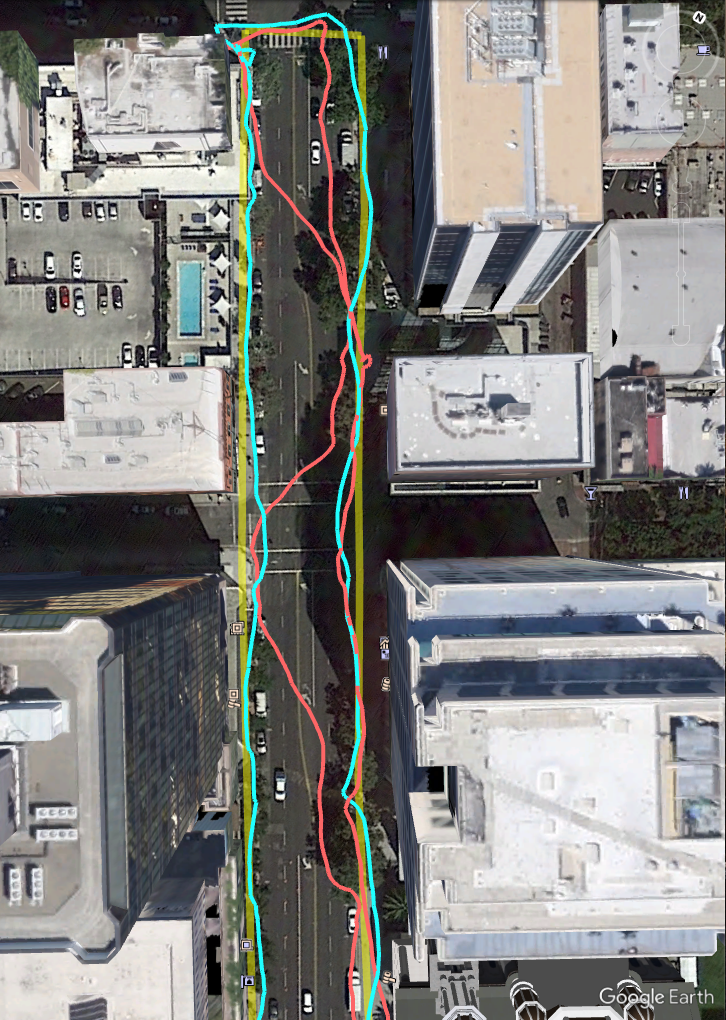
Google's before-and-after picture of the corrections. Yellow is the actual path walked, red is the before 3D corrections, blue is after.
Google promises “spectacular” city GPS improvement with 3D building data
Android GPS will work better in cities thanks to Google Maps' 3D building data.
 arstechnica.com