Yayyyyyy2 area's of interest noted by NHC. The further west AOI is looking to end up in the gulf by next weekend and the east looks to go along the Greater Antilles in the same time frame. GFS still playing catch up with these storms will be interesting what the Euro shows in the next few hours

-
Ever wanted an RSS feed of all your favorite gaming news sites? Go check out our new Gaming Headlines feed! Read more about it here.
Atlantic Hurricane Season 2020 |OT| Tropics don't care
- Thread starter perfectchaos007
- Start date
- OT
You are using an out of date browser. It may not display this or other websites correctly.
You should upgrade or use an alternative browser.
You should upgrade or use an alternative browser.
Want to ask a dumb question - when people mention waves coming off Africa, what exactly do they mean?
Basically they are a line of storms coming off Africa. Not all develop into storms and not all storms form from waves, 60% of Atlantic storms develop from waves. They have some spin but not a circular rotation. Some of them will develop a circular circulation those are classified as depressions then they get stronger from there. The large majority of Atlantic major hurricanes(Cat 3+) develop from waves.
The red circle shows a wave over a couple of days

more in-depth article about them

Why Tropical Waves Are Important During Hurricane Season | The Weather Channel
Here's an in-depth look at tropical waves – areas of increased energy coming from Africa that often give rise to hurricanes. - Articles from The Weather Channel | weather.com
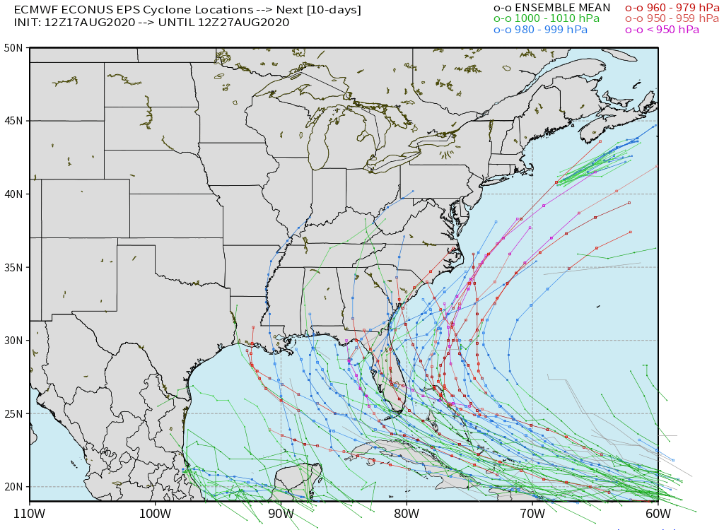
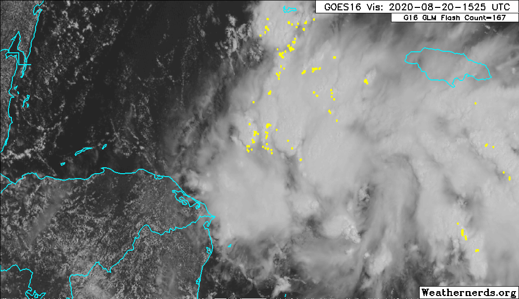
NHC has designated the wave that came off Africa yesterday as invest 98L, Models are starting to catch up to it, shaping up to be a threat to watch in the next 4-8 days depending on where you live.
Here are some long range to give an idea of the potential track. Still have a while to go with this storm and things can change.

Here are some long range to give an idea of the potential track. Still have a while to go with this storm and things can change.
Steering currents do not look good for the US if either two develop. These most likely will not be fish storms.
Shit, that one could hit Florida.NHC has designated the wave that came off Africa yesterday as invest 98L, Models are starting to catch up to it, shaping up to be a threat to watch in the next 4-8 days depending on where you live.
Here are some long range to give an idea of the potential track. Still have a while to go with this storm and things can change.
Apart from the obvious news about Invest 98L, I also learned today that the two hurricane hunter planes are Kermit and Ms. Piggy. Adorable.
Nothing really new, everyone one is waiting for them to form closed circulations so models will hopefully do better. Same general track as before. Hurricane hunters go out to 98L tomorrow so we'll have more data for the models to go off of.
With 98L there seems to be a general split between the models one going a more southerly route through the islands and not really forming until the Gulf if at all the other going north of the islands and being a threat to SFL. Still have a little over 5 days before a potential FL landfall. Seen some annoyance from meteorologist on how models are doing with this storm.
Kinda the same deal with 97L, its gonna depend on how strong and when it enters the gulf but so far no models have made it a major threat unlike 98L. 97L has about the same time frame as 98L with it coming close to land in about 5 days.
Latest 98L model run
Latest 97L model run
If you want a more in depth view, posted yesterday should be a new video tonight.
Latest video from Levi
I don't want to be doom-y(because we don't even have a storm yet) but a track north of the larger islands into SFL could get very scary very quickly. Anyone in SFL should be keeping a close eye on this.
I don't want to be doom-y(because we don't even have a storm yet) but a track north of the larger islands into SFL could get very scary very quickly. Anyone in SFL should be keeping a close eye on this.
Last edited:

OP
OP
Still continuing that trend this season of quantity not strength. September, I feel, we'll see a couple of major storms form
Still continuing that trend this season of quantity not strength. September, I feel, we'll see a couple of major storms form
This is what NHC said in its discussion
If the depression moves on the south side of the guidance envelope, further strengthening would be limited due to land interaction. Conversely, if the system gains more latitude and moves north of these highly topographic islands, it could have the opportunity for more significant intensification. The NHC intensity forecast, which is of low confidence, is roughly near the middle of the guidance envelope.
I'd expect things to change over the next day or so.
I'd be careful what you say with this one. Models have had a tough time grasping these two latest invest buy now some of them are pointing to a possible major with this storm. Still too early to tell as a lot of path factors in play as much noted.Still continuing that trend this season of quantity not strength. September, I feel, we'll see a couple of major storms form
Gfs on board with the storm now. I expect intensity forecast will start to go up soon from nhc. Probably waiting on how it looks as a TS. HWRF has it as a major hurricane going into Florida. If you are in Florida you need to start preparing that this becomes a major storm. There isn't much time either because this storm is flooring it.
And we have TD 14, again will auto update

Also the track for 13 has a hurricane over the bahamas, will be interesting to see what the 12z Euro has, that will like narrow the cone if it comes in line with the other models

Also the track for 13 has a hurricane over the bahamas, will be interesting to see what the 12z Euro has, that will like narrow the cone if it comes in line with the other models
Yeah, I saw the update on TD14, just a couple hours after I told my mom (in Florida) that it looked like it was going to miss us entirely, since pretty much all of the models had it turning north and hitting Louisiana area. And now NHC has it headed right for Texas.. lol.
Well, we could definitely use the rain and hopefully some cooler temperatures.
Well, we could definitely use the rain and hopefully some cooler temperatures.
OP
OP
TD14 might also be a sleeper storm that catches people by surprise, depending on how it tracks over the Yucatan and develops prior. If it can close off before landfall, it will probably carry over to the Gulf where we all know what can happen there in 48 hours or less. Texas and Florida should be on high alert as they will be landfalling possibly within 24 hours of each other. Could be historic next week if those track cones don't shift much with two of the largest metros in the U.S. being hit basically simultaneously.
I was going to ask if we'd had multiple hurricane hits at once beforeTD14 might also be a sleeper storm that catches people by surprise, depending on how it tracks over the Yucatan and develops prior. If it can close off before landfall, it will probably carry over to the Gulf where we all know what can happen there in 48 hours or less. Texas and Florida should be on high alert as they will be landfalling possibly within 24 hours of each other. Could be historic next week if those track cones don't shift much with two of the largest metros in the U.S. being hit basically simultaneously.
Very cool. Just what I wanted.And we have TD 14, again will auto update
Also the track for 13 has a hurricane over the bahamas, will be interesting to see what the 12z Euro has, that will like narrow the cone if it comes in line with the other models
OP
OP
I'm guessing the gulf must have lots of sheer or dry air if the NHC isn't expecting more than a tropical stormTD14, if the track follows as above, will hit a huge pool of red hot water in the Gulf. If it does then it'll explode. Temps there are around 30C.
They are actually a little bullish, but the models are not showing it yet (though they've been terrible all year), plus it needs to form first before they can really make a good call as mentioned above. As an example, the major models are still not even showing this storm properly.I'm guessing the gulf must have lots of sheer or dry air if the NHC isn't expecting more than a tropical storm
We'll know more about both in 24 hours.
Possibly two hurricanes hitting gulf states within 24 hours? Good thing Trump hasn't done anything to take funds away from FEMA recently.
I'm not sure what they're looking at, honestly, unless it's changed in the last day or so. A couple days ago they were saying the gulf was ripe for development and they would have expected anything that went in there to get a lot stronger a lot faster. I guess we'll wait and see.I'm guessing the gulf must have lots of sheer or dry air if the NHC isn't expecting more than a tropical storm
I'm not sure what they're looking at, honestly, unless it's changed in the last day or so. A couple days ago they were saying the gulf was ripe for development and they would have expected anything that went in there to get a lot stronger a lot faster. I guess we'll wait and see.
Its this trough with a bunch of dry air that 14 runs into shearing it and impedes it's development, it'll collapse so if 14 is a bit slower then expected it'll avoid it but then you have the interaction between 13 and 14 that will cause issues for both systems
Wouldn't be surprised if 14 gets named before 13, looking good, about to go into really good conditions, recon is going be in the storm within the hour
Possibly two hurricanes hitting gulf states within 24 hours? Good thing Trump hasn't done anything to take funds away from FEMA recently.
Well, not within 24 hours (not supposed to be here until the weekend at earliest) but yeah. Ugh.
Well, not within 24 hours (not supposed to be here until the weekend at earliest) but yeah. Ugh.
Within 24 hours of each other.
Oop, my bad then. Carry on.
The one in front will be directly influencing the second one's path and will probably leave a weakness in the steering for it to follow depending on it's strength. It's definitely gonna be a dangerous situation if they both blow up.Possibly two hurricanes hitting gulf states within 24 hours? Good thing Trump hasn't done anything to take funds away from FEMA recently.
What a bad time for Cat 6's comment section to go down.
Climate connection's comment section is still in bad shape
Climate connection's comment section is still in bad shape
What are these you are talking about?What a bad time for Cat 6's comment section to go down.
Climate connection's comment section is still in bad shape
Weather underground blog cat 6 that started around 2005, where I and many others went to learn about these storms, IBM bought WU a while ago and shut down the blog earlier this summer. Comment section was always a good place to get information and Jeff Master and Ben Henson blogs are always informative. Master and Henson moved to Yale's Climate Connection but they didn't have a comment section but are building it. People have just been using Cat 6's comment section til then. Does seem like the comment section is still active on the disqus site
This is the latest blog post.

Major hurricane could hit Florida Monday, some models suggest » Yale Climate Connections
And U.S. Gulf Coast residents should monitor a second tropical depression that could strengthen to a tropical storm or a category 1 hurricane.
 yaleclimateconnections.org
ThanksWeather underground blog cat 6 that started around 2005, where I and many others went to learn about these storms, IBM bought WU a while ago and shut down the blog earlier this summer. Comment section was always a good place to get information and Jeff Master and Ben Henson blogs are always informative. Master and Henson moved to Yale's Climate Connection but they didn't have a comment section but are building it. People have just been using Cat 6's comment section til then. Does seem like the comment section is still active on the disqus site
This is the latest blog post.
Major hurricane could hit Florida Monday, some models suggest » Yale Climate Connections
And U.S. Gulf Coast residents should monitor a second tropical depression that could strengthen to a tropical storm or a category 1 hurricane.
OP
OP

It's good news for Houston they are in the bullseye for a Hurricane 5 days out, because forecast almost always shifts when its this far out.
It's good news for Houston they are in the bullseye for a Hurricane 5 days out, because forecast almost always shifts when its this far out.
Holy shit, we're actually going to have side-by-side hurricanes on Monday, aren't we?
OP
OP
Looks like Miami will be hit by a hurricane on Monday, and Houston will be hit by a DIFFERENT hurricane on Tuesday if the forecast holds*Holy shit, we're actually going to have side-by-side hurricanes on Monday, aren't we?
*it wont
**but then again its 2020
I'm seeing double here! Four hurricanes!Holy shit, we're actually going to have side-by-side hurricanes on Monday, aren't we?
I'm losing my shit here in br. This is crazy.Sitting here in NOLA slowly sipping my iced tea trying to split the two
Thread that Laura-Marco needle, NOLA.Sitting here in NOLA slowly sipping my iced tea trying to split the two
That Houston track keeps sliding over towards Louisiana so fuck it let's go wash the covid away I guess.
Link?
Link?