Cape May now has a Tropical Storm Warning. The Philadelphia area is under a "tropical cyclone statement" or something.
-
Ever wanted an RSS feed of all your favorite gaming news sites? Go check out our new Gaming Headlines feed! Read more about it here.
-
We have made minor adjustments to how the search bar works on ResetEra. You can read about the changes here.
Atlantic Hurricane Season 2020 |OT| Tropics don't care
- Thread starter perfectchaos007
- Start date
- OT
You are using an out of date browser. It may not display this or other websites correctly.
You should upgrade or use an alternative browser.
You should upgrade or use an alternative browser.
Central Atlantic invest will likely be upgraded to tropical depression with the 11am advisory
Some early tracks
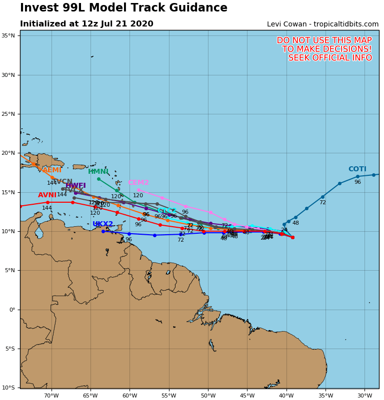
Some early tracks
OP
OP
I was browsing the Hurricane Season tending thing and someone mention this would be Gonzalo I had to do a double take, if this develops further which is likely we'll be through 1/3 of the names before August.
Edit: here is the advisory this will auto update as usual
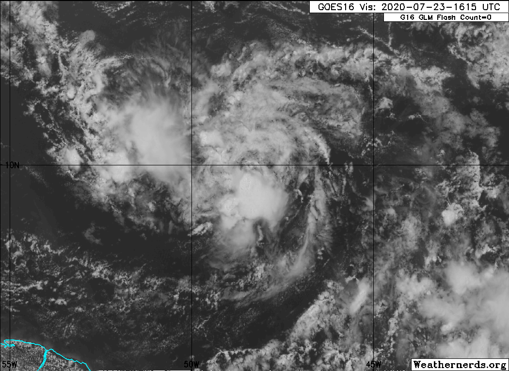
Storm will mainly have to combat dry air to continue to strengthen, Next 24 hours will be very telling of what this storm will be.

Latest Euro ensemble run, could be seeing the start of a train
Last edited:
We officially have TS Gonzalo, the earliest 7th named storm in recorded history.
Tropical Storm Gonzalo Tropical Cyclone Update
NWS National Hurricane Center Miami FL AL072020
850 AM AST Wed Jul 22 2020
...TROPICAL DEPRESSION SEVEN BECOMES TROPICAL STORM GONZALO...
Satellite data indicate that Tropical Depression Seven has
strengthened and is now Tropical Storm Gonzalo with 45 mph
(75 km/h) winds. The intensity forecast will be updated in the
regular advisory at 11 AM AST...1500 UTC.
SUMMARY OF 850 AM AST...1250 UTC...INFORMATION
----------------------------------------------
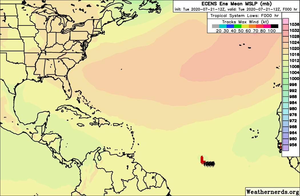
LOCATION...9.9N 43.1W
ABOUT 1250 MI...2010 KM E OF THE SOUTHERN WINDWARD ISLANDS
MAXIMUM SUSTAINED WINDS...45 MPH...75 KM/H
PRESENT MOVEMENT...WNW OR 285 DEGREES AT 12 MPH...19 KM/H
MINIMUM CENTRAL PRESSURE...1003 MB...29.62 INCHES
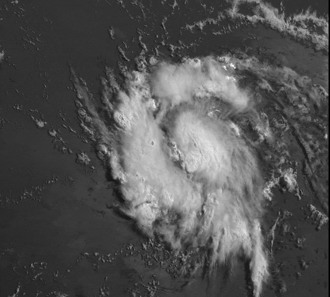
Still looking pretty good though with area where dry air can get in
Tropical Storm Gonzalo Tropical Cyclone Update
NWS National Hurricane Center Miami FL AL072020
850 AM AST Wed Jul 22 2020
...TROPICAL DEPRESSION SEVEN BECOMES TROPICAL STORM GONZALO...
Satellite data indicate that Tropical Depression Seven has
strengthened and is now Tropical Storm Gonzalo with 45 mph
(75 km/h) winds. The intensity forecast will be updated in the
regular advisory at 11 AM AST...1500 UTC.
SUMMARY OF 850 AM AST...1250 UTC...INFORMATION
----------------------------------------------
LOCATION...9.9N 43.1W
ABOUT 1250 MI...2010 KM E OF THE SOUTHERN WINDWARD ISLANDS
MAXIMUM SUSTAINED WINDS...45 MPH...75 KM/H
PRESENT MOVEMENT...WNW OR 285 DEGREES AT 12 MPH...19 KM/H
MINIMUM CENTRAL PRESSURE...1003 MB...29.62 INCHES
Still looking pretty good though with area where dry air can get in
Last edited:
NHC has Gonzalo becoming a Hurricane Thursday, so a potential hurricane threat to the lesser Antilles. The main models generally have a harder time with smaller storms and interaction with dry air, we'll see how this goes.
If Gonzalo becomes a Hurricane it will be the first this year.
There is also a wave after this that should develop, Earliest H name storm is August 3 so that will likely change with either the invest in the Gulf or the wave coming off Africa.
If Gonzalo becomes a Hurricane it will be the first this year.
There is also a wave after this that should develop, Earliest H name storm is August 3 so that will likely change with either the invest in the Gulf or the wave coming off Africa.
Awesome. Just what we needed.NHC has Gonzalo becoming a Hurricane Thursday, so a potential hurricane threat to the lesser Antilles. The main models generally have a harder time with smaller storms and interaction with dry air, we'll see how this goes.
If Gonzalo becomes a Hurricane it will be the first this year.
There is also a wave after this that should develop, Earliest H name storm is August 3 so that will likely change with either the invest in the Gulf or the wave coming off Africa.
Yeah, I've been stocking up on canned food my last few trips to the grocery store. I should be fine to ride out the season. Rarely get any direct hits here anyway. The last big one was Harvey, and we're just far enough from Houston that we never lost power.
So I assume the Trump administration has a plan already drawn up to help mitigate the spread of COVID inside storm shelters should they become necessary?
I'm sure Trump has his sharpie on standbySo I assume the Trump administration has a plan already drawn up to help mitigate the spread of COVID inside storm shelters should they become necessary?
Bet he is winding up his throwing arm as well.
So I assume the Trump administration has a plan already drawn up to help mitigate the spread of COVID inside storm shelters should they become necessary?
Thats more on local governments, some of them have talked about. Some of the ideas are isolating those with symptoms away from those without, Less people per shelter which means more shelters and team members for each new shelter, which leads to more space per person, and some talk about using hotels as shelters. Not sure if there is a great solution until we get faster testing capabilities. Face Coverings will likely be a requirement in common areas.
OP
OP
Yep. We bouta be swimmin to the Astros home openerThe storm in the central gulf has an 80% chance of development now
The storm in the central gulf has an 80% chance of development now
Yea, theres a Recon plane going to it but it is not transmitting data for some reason, People are waiting for that. Good chance we get Hanna later today.
TS Gonzo getting stronger
The storm in the central gulf has an 80% chance of development now
ROFL, I'm heading to port A tomorrow for a few days. Looks like Thursdays is the only beach day. The rest will be games and pot cookies, but at the beach. Currently there isn't much expected in terms of winds or ocean surge, but I'll be checking it frequently and plan to bail of it pulls a Harvey.
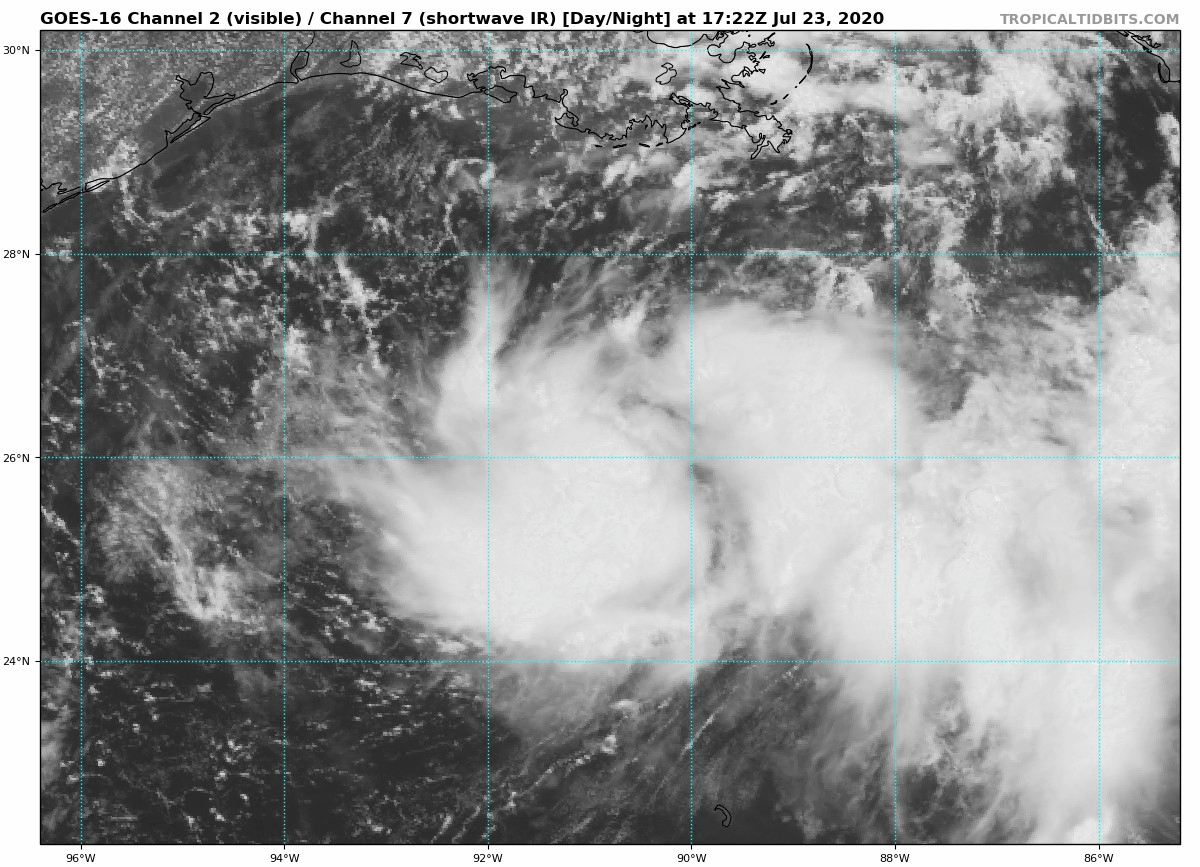
TD 8 has officially formed, NHC not expecting anything strong, Expecting to hit Saturday south of Houston, Since it is the the storm will likely have a chance to get to Hurricane force but not much beyond Cat 1 I'd assume.
INIT 23/0300Z 25.9N 88.2W 25 KT 30 MPH
12H 23/1200Z 26.3N 89.3W 30 KT 35 MPH
24H 24/0000Z 27.0N 90.8W 30 KT 35 MPH
36H 24/1200Z 27.9N 92.4W 35 KT 40 MPH
48H 25/0000Z 28.2N 94.0W 35 KT 40 MPH
60H 25/1200Z 28.5N 95.3W 40 KT 45 MPH
72H 26/0000Z 28.7N 96.8W 35 KT 40 MPH...INLAND
96H 27/0000Z 28.8N 98.1W 25 KT 30 MPH...INLAND
120H 28/0000Z 28.7N 100.5W 20 KT 25 MPH...INLAND
OP
OP
Houston will get the dirty side rain wise. Hopefully some of that rain makes it up to DFW but it looks like we won't get much if any
What dry air can do to a small system overnight, reason why small storms are so hard to predict
From this yesterday
From this yesterday
OP
OP
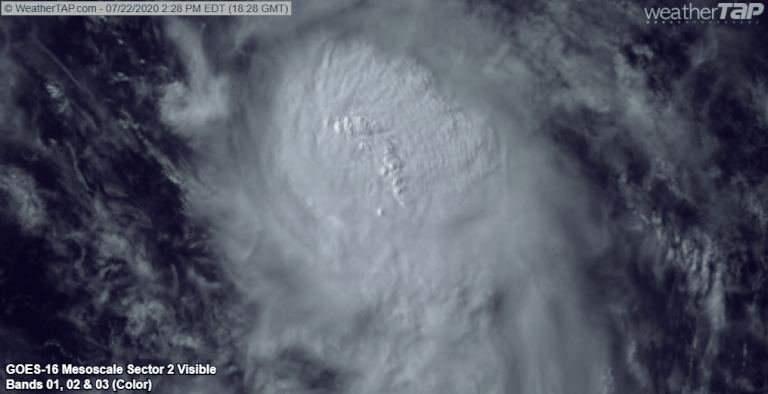
Not yet, NHC still expects it to get to Hurricane status by tomorrow but its definitely struggling right now.
A bit of a run down
Gonzalo is trying its best to gather itself
TD8 looking better then Gonzalo honestly, Wouldn't be surprised if we see it classified as a TS by the 5pm advisory
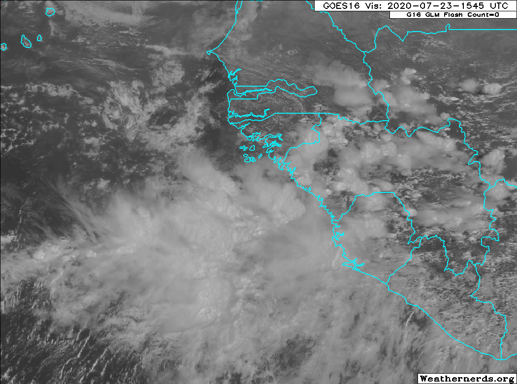
Lastly new wave coming off Africa expected to develop, unlike Gonzalo this wave will have plenty of favorable conditions to develop, several models have been developing it over the past couple of days.

Gonzalo is trying its best to gather itself
TD8 looking better then Gonzalo honestly, Wouldn't be surprised if we see it classified as a TS by the 5pm advisory
Lastly new wave coming off Africa expected to develop, unlike Gonzalo this wave will have plenty of favorable conditions to develop, several models have been developing it over the past couple of days.
OP
OP
A bit of a run down
Gonzalo is trying its best to gather itself
TD8 looking better then Gonzalo honestly, Wouldn't be surprised if we see it classified as a TS by the 5pm advisory
Lastly new wave coming off Africa expected to develop, unlike Gonzalo this wave will have plenty of favorable conditions to develop, several models have been developing it over the past couple of days.
So Gonzalo isn't really anything to worry about (for the US at least) but that wave could end up being a mess. And we're not even in August yet. Great.
So Gonzalo isn't really anything to worry about (for the US at least) but that wave could end up being a mess. And we're not even in August yet. Great.
Wouldn't put Gonzalo off yet, there has been models that take him into the gulf and he could get into the extremely hot waters around Jamaica and SW Cuba, been a while since a storm has been trough there. Right now the best case scenario is that it weakens going into the Caribbean and hits Hispaniola as a TS or TD and that completely dissipates the storm

Also Models will likely be less accurate then normal, reduced air traffic due to Covid has reduced the amount of data these models run off.
Here is the latest Euro run, I'm putting in spoilers because its a long range and I don't want people to take it as reality, anything after 120 gets pretty iffy but this thing could be a monster.
Wouldn't put Gonzalo off yet, there has been models that take him into the gulf and he could get into the extremely hot waters around Jamaica and SW Cuba, been a while since a storm has been trough there. Right now the best case scenario is that it weakens going into the Caribbean and hits Hispaniola as a TS or TD and that completely dissipates the storm
Also Models will likely be less accurate then normal, reduced air traffic due to Covid has reduced the amount of data these models run off.
Here is the latest Euro run, I'm putting in spoilers because its a long range and I don't want people to take it as reality, anything after 120 gets pretty iffy but this thing could be a monster.
As someone who lives in Florida, YOU'RE NOT HELPING MY ANXIETY
As someone who lives in Florida, YOU'RE NOT HELPING MY ANXIETY
We're well off anything hitting Florida and things change daily, the African wave is probably 2+ weeks out from hitting CONUS, nothing to worry about yet.
A hurricane will hit Florida eventually just have to prepare the best you can. I've haven't been directly hit by a hurricane in South Florida since Wilma, its kinda due at this point just have to hope its not a Major.
How do I find the storm surge forecast for corpus Christi? Does such a thing exist? I plan on leaving at 7am just before the winds love from North to west and get above 20 mph sustained.
They usually post them closer to landfall and they'll probably only have them if its a hurricane.
As a Florida resident (Tampa Bay), how far in advance of a hurricane making landfall should you leave home to avoid traffic, etc.? Like 2-3 days? I'm just going to head to my parents' place in GA in the event of a storm, but I'd like to actually get out of here and not leave too late and get stuck.
As a Florida resident (Tampa Bay), how far in advance of a hurricane making landfall should you leave home to avoid traffic, etc.? Like 2-3 days? I'm just going to head to my parents' place in GA in the event of a storm, but I'd like to actually get out of here and not leave too late and get stuck.
Ayyyyy a fellow Tampa Bay resident! I'd say four just to be safe. And if the hurricane changes it's track, well, better safe than sorry.
TS Hanna has formed, she's been taking its time to get its self together despite appearance. To be a broken record, Earliest "H" name storm, taking over Harvey(not that one) from 2005 which formed August 5th, We'll probably of the "I" storm next week. We're gonna be getting to Greek Alphabet by the end of the year.
OP
OP
Looks like It's going to make landfall just south of corpus. Houston may not get a whole lot from this system even though they are on the dirty side the landfall will be a couple hundred miles south
Don't leave unless you need to. If you live in a sturdy building (aka not a mobile home), and aren't in a surge or flood zone, you should be fine.As a Florida resident (Tampa Bay), how far in advance of a hurricane making landfall should you leave home to avoid traffic, etc.? Like 2-3 days? I'm just going to head to my parents' place in GA in the event of a storm, but I'd like to actually get out of here and not leave too late and get stuck.
This is my personal scale:
Cat 3 and below: Stay home
Cat 4: Stay home unless it's expected to be a direct hit
Cat 5: If the eye is coming anywhere near me, GTFO
For reference, I've lived here (Tampa) for almost 30 years. The only times I've ever left was for Charley in '04 (was an expected direct hit. Cat 4 with the eye going right up Tampa Bay), and Irma in '17. I know you've said before that you work for a news station around here, so I'm not sure if you've heard the spiel they usually do where they say it's better to shelter in-place if you can, or go to a local hurricane shelter (in more normal times, obviously), that way you're not contributing to the gridlock, and emergency supplies can get to where they need to be before the storm hits