-
Ever wanted an RSS feed of all your favorite gaming news sites? Go check out our new Gaming Headlines feed! Read more about it here.
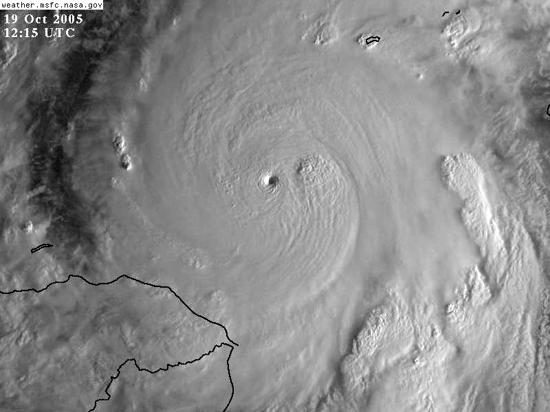
Atlantic Hurricane Season 2019 |OT| The Wish for Fish Storms
- Thread starter perfectchaos007
- Start date
You are using an out of date browser. It may not display this or other websites correctly.
You should upgrade or use an alternative browser.
You should upgrade or use an alternative browser.
Euro just went significantly west...UKMET was the main reason I was still worried, but they have now significantly shifted east as well.
THe models have no idea where this is going within a 100 miles of their track. The standard error when they do no is 50 to 70 miles 24 hours out...
This is also true. The larger and stronger the storm is the more powerful steering currents need to be in order to dramatically cause a turn like the one predicted.Alright I'll throw my two cents in. This storm is much stronger than forecasted. Historically, when a storm is stronger than forecasted, its "heavier" latitude-wise and therefore it will take longer to lift north as the models indicate. This is critical to its interaction with Florida.
in this case these "alt" gov accounts popped up after trump took office to be criticize him as the fed was censoring the official ones. They're not associated to the altright and came about before the alt right movement came into the mainstream after trumps election. They just have very unfortunate twitter handles nowCould we... maybe NOT post things from Twitter with "alt-" anything in the username? Could we just not?
I'm sure Trump will show up somewhere in the next weekfor a photo opto throw some paper towels at people.
Seems like that is the only model showing that W/SW dip, everyone else is showing a swift turn up and out to the NE
Isn't already looking a bit more southerly than that starting point?
I hope they make it out ok, that looks really bad though.

If that track stays true, looks like the eastern seaboard dodged a bullet comparatively
I'll be posting these updates as soon as I get them. A friend of mine works at FLL here. They get updates directly from NOAA.

Broward peeps, you shuttering? I have mostly impact glass, but a few still use a few panels. I'm not worried about shuttering everything for 50-60mph sustained.
I can never make out with these maps. Is that Broward that's now in the cone?
Some weather folks are saying the models are starting to show a small ridge appearing from GA to NC, depending on its strength, this may push Dorian more to the SW. Possible reason Euro began a large shift west for the short term modeling.
When it's that close you need to watch anyway. If the track is even off by 30 miles it could be the difference between a landfall or not.If that track stays true, looks like the eastern seaboard dodged a bullet comparatively
I can never make out with these maps. Is that Broward that's now in the cone?
The tip of it almost, they keep saying it's West Palm area but a tiny shift and Broward is in it
I can never make out with these maps. Is that Broward that's now in the cone?
Barely, but it's the windspeed for us right now. Based on current models, we won't get a direct hit, but Broward will most likely get hurricane force winds, either sustained or gusts. Maybe enough to knock out power and toss debris. We don't know yet.
Also a reminder that Trump just took money from FEMA to pay for ICE. Hope people remember this on election day.
Uh that sounds bad...Some weather folks are saying the models are starting to show a small ridge appearing from GA to NC, depending on its strength, this may push Dorian more to the SW. Possible reason Euro began a large shift west for the short term modeling.
It hasn't dodged anything yet, the westmost fourth is still a possible track, remember that's not the effected area with the track in the center, but rather the range of all possible tracks with it being possible it brushes a huge chunk of the east coast of floridaIf that track stays true, looks like the eastern seaboard dodged a bullet comparatively
I can never make out with these maps. Is that Broward that's now in the cone?
Barely, Lighthouse point area is in it
Barely, but it's the windspeed for us right now. Based on current models, we won't get a direct hit, but Broward will most likely get hurricane force winds, either sustained or gusts. Maybe enough to knock out power and toss debris. We don't know yet.
I'm prepared mentally for tropical storm winds. Hurricane force winds worry me because it's not specific, especially with the wind speeds of this hurricane... like saying hurricane force winds while on the periphery of the storm when the winds of this hurricane are 185mph are terrifying because I don't know what to expect.
Tropical storm is 39-75mph with hurricane force winds that can be anything from 75-185 in my mind at the moment...
Tropical storm is 39-75mph with hurricane force winds that can be anything from 75-185 at the moment...
I think "hurricane force" is between 75-110, and anything over that they'll refer to as "major hurricane force."
I think "hurricane force" is between 75-110, and anything over that they'll refer to as "major hurricane force."
But they don't seem to specify expectation of winds for watches. They only specify when labeling the actual system.
And guess who's in that small tip. ¯\_(ツ)_/¯The tip of it almost, they keep saying it's West Palm area but a tiny shift and Broward is in it
It hasn't dodged anything yet, the westmost fourth is still a possible track, remember that's not the effected area with the track in the center, but rather the range of all possible tracks with it being possible it brushes a huge chunk of the east coast of florida
I get that, I'm just saying if it stays on the track.
I live in Yulee north of Jacksonville. Depending on how the next 24hrs are I may leave. My gf Mom and sister think I'm too worried because it will be weaker if it gets up here. But if it's anything like Matthew that did a lot of flooding and damage to this area

If that track stays true, looks like the eastern seaboard dodged a bullet comparatively
So this is a poor understanding of what the map is showing. Don't focus on the dots or the center of the cone, the center isn't a higher likelihood than the rest of the cone.
There is a lot of model hugging going on in this thread. You need to focus on what all of them are showing as trends and not take their output as verbatim and remember that they all have their biases. We're nearing the point where the focus should move to the output of the higher resolution mesoscale models as the global models aren't as good indicators the closer we get.

ok
Fuck sake man, can this hurricane make up its fucking mind?!
Those are pretty close to the way it's been for the last 24-48 hours. It might hit the coast, it might not.
Please don't start this again.
