Ah okay. Sorry for sharing it then.He's a pretty in/famous storm chaser.
He has a vested interest in embellishing storms, but Cat 5s are no joke.
-
Ever wanted an RSS feed of all your favorite gaming news sites? Go check out our new Gaming Headlines feed! Read more about it here.
Atlantic Hurricane Season 2019 |OT| The Wish for Fish Storms
- Thread starter perfectchaos007
- Start date
You are using an out of date browser. It may not display this or other websites correctly.
You should upgrade or use an alternative browser.
You should upgrade or use an alternative browser.
Katrina actually made landfall as a 3.Jesus Christ. Please stay safe all you down in South Florida. I have family that live down there and I've already told them to gtfo just in case and they have thankfully. Can't take any chances with a hurricane this strong.
Not sure how reliable this guy is, but he has been apparently keeping up a running commentary for a few hours now.
Wait wait, does this fucker take his kids with him when he chases these storms?!
No he basically does rescue ops for his "hype" storm chaser persona.Wait wait, does this fucker take his kids with him when he chases these storms?!
Damn. I had no idea. I just saw his tweets while I was going through two. I wouldn't have shared it if I knew he was just a hype man.No he basically does rescue ops for his "hype" storm chaser persona.

Broward peeps, you shuttering? I have mostly impact glass, but a few still use a few panels. I'm not worried about shuttering everything for 50-60mph sustained.
Not yet, haven't seen the need to. Can get it done pretty quick if needed.
I don't need luck. I've got a case of IBC Root Beer. Bring it on!
But seriously, storm, stay out at sea.
Quote from americanwx forum:
Just git a report from our closest friend. Their concrete roof has blown completely off and try are hiding in the stone generator room in the back yard now.
Friends in Marsh Harbour now in attic as surge is filling their house.
Finishing our shuttering in about 30 minutes. Impact glass in most places but not all, so the shutters come out.Broward peeps, you shuttering? I have mostly impact glass, but a few still use a few panels. I'm not worried about shuttering everything for 50-60mph sustained.
Considering UKMET up to this point, this is VERY good news.
Looks like most of the models are expecting an extended stall over the northern Bahamas and turn north now. HMON had a run a few days ago that was exactly that, and I didn't believe it when I saw it.
I feel like I'm missing something obvious here but how is it tied for third strongest? Shouldn't top three be the 190mph storm and two of the 185mph storms? I feel dumb because I keep reading this tweet and it's not sounding right to me.
EDIT: nvm, I get it now. Took a third or fourth look at it after posting and it made sense.
Yes it is. It's a shame the Bahamas have to die for this though. That place is going get devastated.
Finally, some good news for Florida. I had a sense of dread all night from yesterday's tracks.
Poor Bahamas... I'm afraid to see the aftermath of that. It would look apocalyptic.
Poor Bahamas... I'm afraid to see the aftermath of that. It would look apocalyptic.
Hurricanes always make you feel like a horrible person when the good news on your end means another place is going to get absolutely fucked.
Good news but we're still more than 24 hours out so they don't mean much until it gets further along
TWC just said the average 48 hour track prediction error is 70 miles...so stay vigilant. That's a big 70 miles in this storms case.
Yep. 70 miles west and this storm is tearing up the Florida Atlantic Coast, with how close the expected track already is. Stay aware and alert.
12Z models so far are good news for Florida. If the Euro is also further east then it will be great news.
I won't be breathing any easier until the system stalls.. Where it stalls will say everything. This is an unprecedented hurricane that up until 5 days ago was supposed to not even be a strong Tropical storm.
Thoughts are with the folks in the Bahamas..... As far as Florida and mainland US
stay vigilant!
Thoughts are with the folks in the Bahamas..... As far as Florida and mainland US
stay vigilant!
Recon finding winds indicating it's probably stronger than 180MPH now...
190MPH is the record for an Atlantic hurricane.
190MPH is the record for an Atlantic hurricane.
I live in Melbourne with my wife. The models look a lot better for us and our walls are thick concrete, but there's no way we're staying here when a shift could put us in the eye. Luckily, my cousin lives on the west side of Orlando so we have a place to escape to that's nearby.
Past Tuesday you should be fine to ship to Miami.May I know the estimated on when all this will be over?
I do no think it's a good time to have an expensive item shipped to Miami, Florida. To my courier. But I'm obliged to order the item soon :/
Even if this stays East of FL and doesn't make landfall St Augustine will be getting cat 3/4 winds yeah? Trying to convince my mom to drive over to Gainesville and wait it out. She has storm shutters and her building is new so she should be fine but A1A is prone to flooding so I feel she'll be trapped inside for awhile until it receeds.
How close to the coast is she? Honestly Lightus if this fucker doesn't slow down in the next 12hrs she should drive inland. At least I would. However that is a personal choice, and maybe she can wait till local officials issue evacuation orders.Even if this stays East of FL and doesn't make landfall St Augustine will be getting cat 3/4 winds yeah? Trying to convince my mom to drive over to Gainesville and wait it out. She has storm shutters and her building is new so she should be fine but A1A is prone to flooding so I feel she'll be trapped inside for awhile until it receeds.
This is an unprecedented storm. HOLY SHIT!
It shows how much we still need to understand about meteorology. This was not even supposed to be a strong TS 5 days ago. Today we have arguably the strongest Hurricane on record in the North Atlantic.
How close to the coast is she? Honestly Lightus if this fucker doesn't slow down in the next 12hrs she should drive inland. At least I would. However that is a personal choice, and maybe she can wait till local officials issue evacuation orders.
She lives on the intercostal so less than a mile from the beach. She's pretty stubborn so not sure if she'll listen to my advice. Can't wait for this thing to pass already so I can stop worrying haha
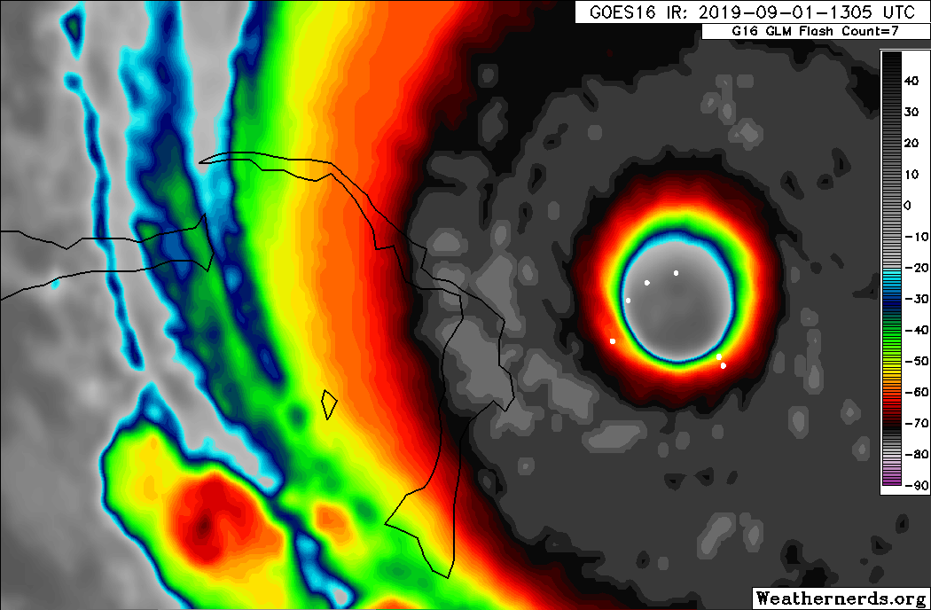
763
WTNT65 KNHC 011644
TCUAT5
Hurricane Dorian Tropical Cyclone Update
NWS National Hurricane Center Miami FL AL052019
1245 pm EDT Sun Sep 01 2019
...CATASTROPHIC CATEGORY 5 DORIAN MAKES LANDFALL ON ELBOW CAY IN THE
ABACOS...
Data from an Air Force Reserve Hurricane Hunter aircraft and
satellite data indicate that Dorian has made landfall at 1240 pm
EDT (1640 UTC) in Elbow Cay, Abacos. The winds have increased
to 185 mph (295 km/h) with the minimum central pressure falling to
911 mb (26.90 inches).
This is a life-threatening situation. Residents there should take
immediate shelter. Do not venture into the eye if it passes over
your location.
Hazards:
- Wind Gusts over 220 mph
- Storm Surge 18 to 23 feet above normal tide levels with higher
destructive waves
These hazards will cause extreme destruction in the affected areas
and will continue for several hours.
SUMMARY OF 1245 PM EDT...1645 UTC...INFORMATION
----------------------------------------------
LOCATION...26.5N 77.0W
ABOUT 5 MI...10 KM E OF GREAT ABACO ISLAND
MAXIMUM SUSTAINED WINDS...185 MPH...295 KM/H
PRESENT MOVEMENT...W OR 275 DEGREES AT 8 MPH...13 KM/H
MINIMUM CENTRAL PRESSURE...911 MB...26.90 INCHES
$$
Forecaster Avila/Blake
BOLDED!!
Movement back up to 8mph.
That's not good for Florida right?
Isn't this thing supposed to be slowing down by now?
Not quite as Allen topped out at 190mph. Still it's staggeringly strong and Allens record could be beaten.This is an unprecedented storm. HOLY SHIT!
It shows how much we still need to understand about meteorology. This was not even supposed to be a strong TS 5 days ago. Today we have arguably the strongest Hurricane on record in the North Atlantic.
Moving faster would be bad for FL yes. Reading chatter from some Mets they say its due to variables expecting the storm to be at a different position and forward speed than what is happening, along with no model expecting this storm to be what it is right now. No model had a CAT5 with close to 900mb pressure and 185 sustained winds at this point in time on the track.Wouldnt moving faster be bad for Florida? Why would that coincide with UKMet going east?
I am hoping the next model runs take the new forward speed and current location into consideration.
That's not good as all the current models rely on a multi hour stall for most of the day, without the stall all current forecasts will be off and the probability of it hitting the Florida coast head on increases exponentially